GIS and Remote Sensing articles

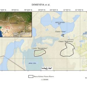
Rangeland diversity as a forage resource for wild ungulates in the Barsa Kelmes nature reserve (Kazakhstan)

Authors: Dimeyeva L.A., Salmukhanbetova Z. K., Malakhov D.V., Wunderlich J.

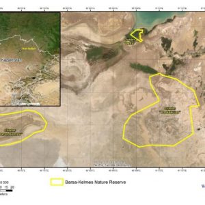
Abstract: The nature reserve was founded in 1939 in the limits of the Barsa Kelmes Island (the Aral Sea, Kazakhstan) for the conservation of the saiga antelope (Saiga tatarica) and goitered gazelle (Gazella subgutturosa). In 1953 kulan from Turkmenistan (Equus hemionus kulan) were introduced to the island.

Читать далее

Remote sensing as a tool of biological conservation and grassland monitoring in mountain areas of Southeastern Kazakhstan

Authors: Dmitry V. Malakhov, Olga V. Dolbnya

Abstract: Grassland degradation, as a worldwide phenomenon, has economic and bio-conservation aspects. Degradation of mountain grasslands severely impacts the ecosystem stability in fragile mountain environments and may destroy habitats of many endemic and endangered species. One of the significant triggers of mountain grassland degradation, along with possible consequences of climate change, is massive overgrazing.

Читать далее

Soil Salinity Estimation for South Kazakhstan Based on SAR Sentinel-1 and Landsat-8,9 OLI Data with Machine Learning Models

Authors: Ravil I. Mukhamediev, Timur Merembayev, Yan Kuchin, Dmitry Malakhov, Elena Zaitseva, Vitaly Levashenko, Yelena Popova, Adilkhan Symagulov, Gulshat Sagatdinova and Yedilkhan Amirgaliyev

Abstract: Climate change, uneven distribution of water resources and anthropogenic impact have led to salinization and land degradation in the southern regions of Kazakhstan. Identification of saline lands and their mapping is a laborious process associated with a complex of ground measurements. Data from remote sensing are widely used to solve this problem. In this paper, the problem of assessing the salinity of the lands of the South Kazakhstan region using remote sensing data is considered.

Читать далее

A New Method for Land Degradation Assessment in the Arid Zone of Republic of Kazakhstan

Abstract

The problem of land degradation, being extremely actual over the planet and especially in arid zones, requires imminent scientific attention to outline territories affected with degradation, and develop effective measures to withstand the problem. The use of remotely sensed data proves as a cost-effective and informative tool for land surface monitoring. Moreover, remote sensing is sometimes the only way to comprehensively imagine the current processes over huge territories. The main question of remote sensing data application is the accuracy of methods used to obtain certain land characteristics. The joint analysis of ground and satellite data is indispensable at all the remote sensed algorithm development stages. In the current chapter the new index of land degradation assessment is described. The index has been under development for several years and has strong ground-truth support with data gathered in the arid zone of Kazakhstan. The new index considers the condition of plant cover, the moistening regime, and bare soil’s spectral parameters. Initially developed for Landsat-8 data in south-eastern Kazakhstan, the index was applied for the entire arid zone of Kazakhstan. There is no doubt, the new index could be of use at various applications related to the problem of environmental degradation all over the arid belt of Eurasia, where the problem of aridization becomes most actual for Asian countries.

Читать далее
Миниатюры нет

The assessment of heavily overgrazed mountain pastures with use of satellite and ground data

Authors: Dmitry Malakhov – 1, Evgenya Senyak – 2
1 – Institute of Zoology MS RK, Almaty, Republic of Kazakhstan
2 – Association for the Conservation of Biodiversity of Kazakhstan, Almaty, Kazakhstan

Aims: To evaluate the condition of natural pastures within the protected area of Upper Koksu Wildlife Sanctuary (UKWS) and to provide recommendations on sustainable management of natural resources of the area.

Читать далее

Predicting suitable breeding areas for different locust species – A multi-scale approach accounting for environmental conditions and current land cover situation

Abstarct

In this study, we present a fused multi-scale approach to model habitat suitability index (HSI) maps for three different locust species. The presented methodology was applied for the Italian locust (Calliptamus italicus, CIT) in Pavlodar oblast, Northern Kazakhstan, for the Moroccan locust (Dociostaurus maroccanus, DMA) in Turkistan oblast, South Kazakhstan and for the desert locust (Schistocerca gregaria) in Awash river basin, Ethiopia, Djibouti, Somalia.

Читать далее

An Ecological Niche Model for Dociostaurus maroсcanus, Thunberg, 1815 (Orthoptera, Acrididae): The Nesting Environment and Survival of Egg-Pods

Authors: Dmitry Victorovich Malakhova – 1, Boris Vasilievich Zlatanov – 2

1 – Joint Stock Company “National Center for Space Research and Technology”, Almaty, 050010, Kazakhstan.
2 – Institute of Zoology, Ministry of Education and Sciences, Almaty, 050060, Kazakhstan.

Abstract

Since the earliest times, the problem of the locust has been a very serious one for agriculture and food production in particular. Devastating locust plagues are known from the Old and the New World where locust swarms terrified the earliest settlement and towns, leaving not a single green branch on the fields.

Читать далее

Comparative analysis of the distribution and habitats of two Eremias species (Reptilia, Lacertidae) using niche-based GIS modeling

Authors: Tatjana N. Dujsebayeva, Dmitry V. Malakhov, Nikolay N. Berezovikov, Xianguang Guo, Jinlong Liu, and Alexander V. Cherednichenko

The distribution and habitat characteristics of two Eremias species (E. arguta and E. stummeri) from contiguous areas of southeastern Kazakhstan, northeastern Kyrgyzstan, and western Xinjiang, China, were analyzed using GIS modeling. We show that both species are dry-steppe-adapted xerophilous lizards with sclerophilic and partially petrophilic specialization. In spite of the visible similarity of the ecological niches (ENs) occupied by E. arguta and E. stummeri, the latter differs in a number of key variables. While most of the precipitation variables, the radiation of the winter and off-season months, and afternoon (PM) humidity are most important for E. arguta habitats, the habitats suitable for E. stummeri are limited by temperature variables, radiation during most of the year, and morning (AM) humidity.

Читать далее

Species distribution model of Varanus griseus caspius (Eichwald, 1831) in central Asia: an insight to the species’ biology

Authors: Dmitry V. Malakhov and Marina A. Chirikova

Abstract: A species distribution model has been developed for one of the most well-studied varanid lizards — Varanus griseus caspius. The model was developed based on several hundred documented localities of the lizard and a number of abiotic variables using statistical and GIS-based approaches. The results of evaluation using the model demonstrated the appropriate spatial accuracy of the model.

Читать далее